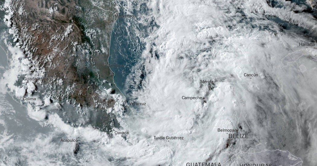
A broad and slightly swirling mass of clouds off the coast of Mexico that will most likely dump anywhere from six to 15 inches of rain across portions of the western Gulf Coast could become Alberto, the first named storm of the year.
The storm, in the Bay of Campeche, was producing tropical-storm-force winds of 40 miles per hour Tuesday morning but was not organized enough to be considered a tropical cyclone.
Tropical storm warnings were issued for portions of the Texas and Northeast Mexico coast Tuesday morning. Forecasters said the system could become a tropical storm by Wednesday, though it may fall short.
Its winds are strong enough to qualify as a tropical storm, but its nature — disorganized and spread out — may prevent it from doing so. It’s difficult to know the exact path the storm will take, though forecasters believe the most likely scenario is for it to make landfall in northeastern Mexico. Regardless, most forecast models indicate that places like coastal Texas will be on the wet side of the storm.
A plume of moisture associated with this storm is expected to surge out of the Caribbean into coastal Texas, bringing widespread rainfall of six to 10 inches. As the bulk of moisture surges into Texas late Tuesday night, the risk for flash flooding increases. Up to three inches of rain is forecast to fall per hour, potentially overwhelming streams and creeks, forecasters warned.
Here are key things to know about the possible storm
-
Heavy rain is expected to increase in Texas from Tuesday night into Wednesday, with the most significant potential for heavy rainfall in Houston and south through Corpus Christi.
-
Tropical storm warnings have been issued for portions of the Texas and Northeast Mexico coast, where tropical storm conditions are likely within the next 36 hours.
-
Several days of heavy rainfall are also expected across portions of southern Mexico and Central America.
If this tropical disturbance takes on tropical-cyclone characteristics and maintains sustained winds of 39 miles per hour or greater, it will be called Alberto. It would be the first storm of what is forecast to be a very active hurricane season.
In addition to the rain, east-to-northeast winds are expected to gradually strengthen over the next couple of days, especially along the Louisiana and Texas Gulf Coasts. Although wind is not the most significant concern with this system, the wind field could be rather expansive and spread far north of the center, with widespread winds gusting over 45 miles per hour along the coast.
With persistent onshore winds, some moderate coastal flooding and a storm surge of one to four feet could also occur. Another threat is rip currents, which will increase along Gulf Coast beaches in the coming days.
#Storm #Texas #Mexico #Tropical #Storm #Alberto,
#Storm #Texas #Mexico #Tropical #Storm #Alberto
