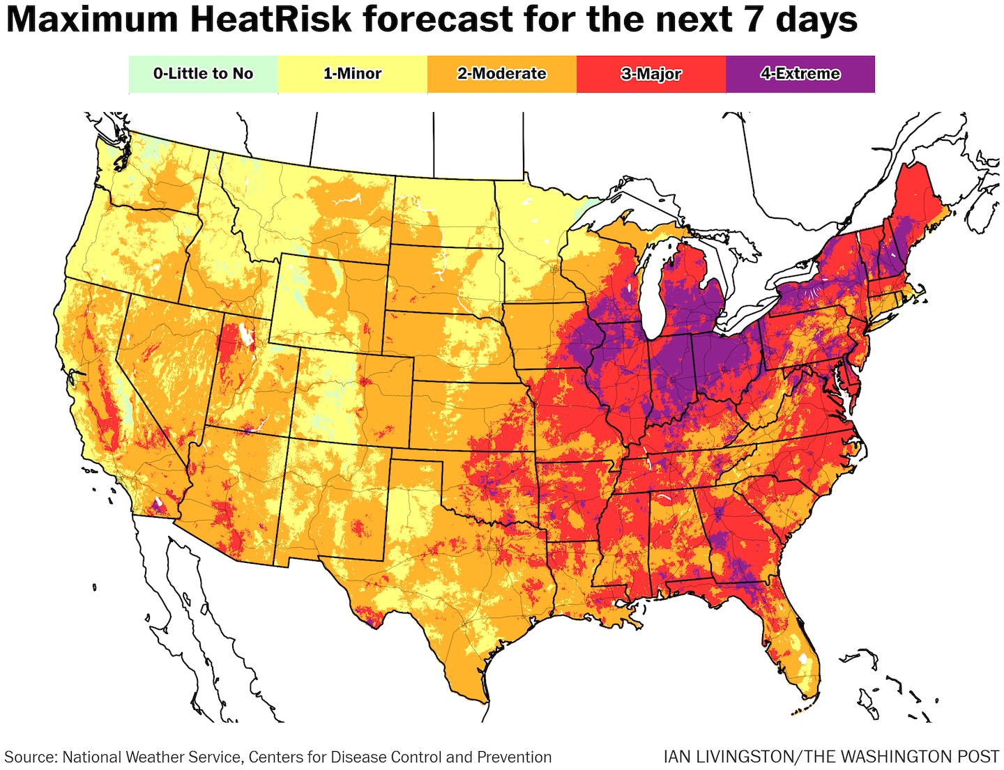
The federal government’s new HeatRisk outlooks — highlighting dangers to people’s health — indicate widespread potential for major to extreme effects. A Level 4 of 4 or extreme HeatRisk affects parts of a dozen states. A much larger area is expecting Level 3 or major HeatRisk areas.
Cities from Chicago to Cincinnati in the Midwest and Philadelphia to Atlanta in the East are forecast to reach Level 4 at some point during the next week.
“This level of rare and/or long-duration extreme heat with little to no overnight relief affects anyone without effective cooling and/or adequate hydration,” the Weather Service wrote.
What areas are under heat alerts?
Heat advisories and warnings stretch from the lower Great Lakes and Ohio Valley through the northern Mid-Atlantic and New England, including much of Maine. About 70 million people are under these heat alerts.
Detroit and Flint in Michigan, Fort Wayne and Marion in Indiana, and Defiance in Ohio have excessive-heat warnings in place through Friday. Temperatures are forecast to rise as high as 95 to 100, and heat indexes — a measure also taking into account humidity — could rise to around 105.
Heat alerts cover most if not the entirety of Ohio, Pennsylvania, New York, Vermont, Massachusetts, Connecticut and New Jersey.
Excessive-heat watches also cover portions of the same area, including Hartford, Conn.; Philadelphia; and parts of the Boston metro northward into southeastern Maine.
Where will it be the hottest?
East of the Mississippi River, the hottest conditions initially will focus in the Ohio Valley and western Pennsylvania. Temperatures in the low and mid-90s Tuesday will climb to near 100 Friday and Saturday.
A zone from northern Kentucky to the Mid-Atlantic and southward may see the most enduring heat, with highs in the 90s rising to near 100 over the weekend.
Where is the heat most unusual?
Through Thursday, locations from the Great Lakes to Pennsylvania as well as New England will feel the most unusual heat compared to normal. Into the weekend, that area probably shifts southward to include much of the Midwest and Mid-Atlantic.
Afternoon temperatures as much as 20 to 25 degrees above normal are forecast for Maine on Wednesday.
The Weather Service office serving the area around Portland, Maine, said the predicted heat between Tuesday and Thursday would be the most intense since July 2011. Meanwhile, the Weather Service office serving Burlington, Vt., said Montpelier could see its hottest weather in 30 years Wednesday.
What records could be set
Dozens of record-hot afternoon highs in the 90s to near 100 and warm overnight lows in the 70s to near 80 are likely to be threatened daily through the weekend.
Some of the many calendar-day records that could fall through the weekend include:
- Syracuse, N.Y., on Tuesday: The second record high in a row is possible, with a high of 96 forecast.
- Millinocket, Maine, on Wednesday: A forecast of 97 would beat the record of 95.
- Manchester, N.H., on Thursday: The forecast of 99 would beat the record of 98.
- Philadelphia on Friday: Temperatures around 100 could test or top the record of 99.
- Charleston, W.Va., on Saturday: A forecast high of 97 is near the record of 98.
- Washington on Sunday: The forecast for the capital city is 97, which is near a record of 98 for the day.
Locations where high heat is less common but multiple daily records are possible include Pittsburgh; Hartford; Bangor, Maine; areas around Boston and portions of the Appalachians.
How hot has it already been?
The heat wave was in its infancy Monday, but some impressive numbers were still observed. In Ohio, it got up to 99 in Toledo. A number of calendar-day record highs were breached in the broader region.
Some notable records include:
Numerous record-warm lows were also newly established Monday in the same areas.
The northernmost areas seeing extreme heat through midweek will get some relief this weekend into early next week as a cold front passes. A break may mean a few days closer to average rather than any sustained cool-down.
To the south, the heat may ease only slightly early next week — with temperatures close to normal early-summer levels.
As June ends and July begins, the most reliable computer weather models are projecting hotter-than-normal conditions across much the nation.
Is climate change making this worse?
Global temperatures have been at record levels for a year because of both the El Niño climate pattern and human-caused climate warming. With El Niño having dissipated and La Niña taking over, global temperatures should come down somewhat in the coming months.
The Climate Shift Index from Climate Central, a science communications organization based in Princeton, N.J., indicates that human-caused climate change is making this week’s record testing heat at least 1.5 to 2 times more probable.
#weeks #heat #wave #heat #alerts #ends,
#weeks #heat #wave #heat #alerts #ends
