Evacuations due to flash flood emergency in Ruidoso area
The rainfall is impacting the Blue 2 and South Fork Fires burn scars
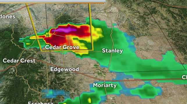
GOOD AFTERNOON, EVERYONE. I WANT TO BRING YOU UP TO DATE ON THE POTENTIALLY VERY DANGEROUS WEATHER TAKING PLACE IN THE RUIDOSO AREA, RIGHT NOW. BIG BURN SCARS. AS YOU KNOW, ARE ENCOMPASSING THIS AREA A LITTLE BIT OF RAIN CAN HAVE FLOODING DEVASTATION, AND YOU ADD SEVERE STORMS TO IT. IT MAKES IT A MESS. NOW, FORTUNATELY, THE ONLY GOOD THING GOING ON HERE IS THAT THIS REGION SHOULD BE EVACUATED. BUT IN CASE IT ISN’T EVACUATED, I WANT TO GIVE YOU AN IDEA OF WHAT’S HAPPENING RIGHT NOW. FIRST OF ALL, WE’RE GOING TO START OFF WITH THE SEVERE THUNDERSTORM WARNING IN EFFECT UNTIL 3 P.M. THIS IS A DESTRUCTIVE THUNDERSTORM. WHY IS IT DESTRUCTIVE? BECAUSE IT HAS THE POTENTIAL FOR SOME BASEBALL SIZED HAIL. WHERE WOULD THAT BE LOCATED? WELL, THERE YOU SEE RUIDOSO, AND IT’S, UH. WOW, YOU KNOW, THIS IS A BIG STORM. IT’S OVER THE DRAINAGE AREA WHERE THE BURN SCAR IS. AS WELL. BUT IT’S GOT THIS BIT OF A DRIFT TO IT IN A SOUTHERLY DIRECTION. SO, AGAIN, NO ONE SHOULD BE HERE TO BEGIN WITH BECAUSE IT’S EVACUATED. BUT IF YOU ARE, GET INSIDE A STURDY BUILDING. NEXT WE HAVE THE FLASH FLOOD WARNING. IN EFFECT, WE HAVE SOME AREAS PICKING UP MORE THAN AN ESTIMATED AN INCH OF RAIN OVER A BURN SCARRED AREA. FLOODING COULD BE A VERY BIG DISASTER THROUGHOUT THE REGION HERE. SO A FLASH FLOOD WARNING IS IN EFFECT THROUGHOUT THE RUIDOSO AREA UNTIL 5 P.M. FOR TONIGHT. BIGGER PICTURE WE DO HAVE THE FLASH FLOOD WATCHES IN EFFECT OVERNIGHT THROUGHOUT THE NORTHERN BURN SCAR AREAS AND THE SOUTHERN BURN SCAR AREAS. BUT THAT’S NOT ALL. WE ALSO HAVE THE POTENTIAL FOR SOME SEVERE STORMS WITH VERY LARGE HAIL AND VERY DAMAGING WIND POTENTIAL. AND YOU SEE THAT THROUGHOUT MUCH OF EASTERN PORTIONS OF NEW MEXICO, ON INTO THE NORTHEASTERN PORTION OF THE STATE, THAT DOES INCLUDE THE RUIDOSO AREA. HENCE THE SEVERE THUNDERSTORM WARNING IN THE AREA. THIS SEVERE THUNDERSTORM JUST WENT THROUGH EDGEWOOD WITH GOLF BALL TO PING PONG SIZED HAIL. NOW IT’S WORKING THROUGH CEDAR CREST, SO CEDAR GROVE, I SHOULD SAY, AND THIS HAS BEEN EXTENDED INTO THE CEDAR GROVE AREA. SO THERE YOU HAVE IT. TAKE SHELTER. THE CEDAR GROVE AREA FOR GOLF BALL SIZED HAIL THERE ON INTO THE GOLDEN AREA AS WELL. AND A BIG STORM WITH LARGE HAIL AROUND THE WILLARD AREA. IT’S GOT A LITTLE BIT OF A SOUTHERLY DRIFT TO IT RIGHT NOW, AND THAT’S WHY THAT SEVERE THUNDERSTORM WARNING HAS BEEN EXTENDED TO THE SOUTH. BUT AGAIN, JUST GIVING YOU A HEADS UP, WE DO HAVE THAT DESTRUCTIVE STORM POTENTIAL WITH THE SEVERE STORM, WITH THE BASEBALL SIZED HAIL TO THE NORTH OF RUIDOSO, WHICH SHOULD BE AN EVACUATED AREA, AND THE FLASH FLOOD WARNING THAT CONTINUES UNTIL 5:00. FOR TONIGHT, WE’
Evacuations due to flash flood emergency in Ruidoso area
The rainfall is impacting the Blue 2 and South Fork Fires burn scars
Mandatory evacuations are in effect after a flash flood emergency was issued for downstream areas into Ruidoso and Alto, according to the Lincoln County Office of Emergency Management.KOAT Chief Meteorologist Joe Diaz provided a look at the latest forecast in the video player above on the emergency weather situation. Be aware: Current weather alerts in your areaThe situation is labeled as extremely dangerous and the rainfall went over both the Blue 2 Fire and South Fork Fire burn scars. The south-central Lincoln County region has experienced at least 1 inch of rainfall with some getting up to two and a half inches, according to the National Weather Service. The emergency is in effect until 4:15 p.m. Wednesday. Thunderstorms in the area are producing heavy rain over both burn scars. The runoff from the rain will cause elevated water levels to some drainages downstream of the Blue 2 Fire burn scar.Interactive radar: New Mexico weather coverage from KOAT 7 WeatherPeople in the area are being asked to seek higher ground as soon as possible. The flood warning is a life-threatening situation.Be sure to download the KOAT App to receive customized weather alerts. You can watch the latest forecast on the app, too.Check Live, Interactive RadarLive Weather ConditionsSevere weather alerts for your areaDownload the KOAT App on iPhoneDownload the KOAT App on Android
Mandatory evacuations are in effect after a flash flood emergency was issued for downstream areas into Ruidoso and Alto, according to the Lincoln County Office of Emergency Management.
KOAT Chief Meteorologist Joe Diaz provided a look at the latest forecast in the video player above on the emergency weather situation.
Be aware: Current weather alerts in your area
The situation is labeled as extremely dangerous and the rainfall went over both the Blue 2 Fire and South Fork Fire burn scars. The south-central Lincoln County region has experienced at least 1 inch of rainfall with some getting up to two and a half inches, according to the National Weather Service.
The emergency is in effect until 4:15 p.m. Wednesday. Thunderstorms in the area are producing heavy rain over both burn scars. The runoff from the rain will cause elevated water levels to some drainages downstream of the Blue 2 Fire burn scar.
Interactive radar: New Mexico weather coverage from KOAT 7 Weather
People in the area are being asked to seek higher ground as soon as possible. The flood warning is a life-threatening situation.
Be sure to download the KOAT App to receive customized weather alerts. You can watch the latest forecast on the app, too.
#Evacuations #due #flash #flood #emergency #Ruidoso #area,
#Evacuations #due #flash #flood #emergency #Ruidoso #area

