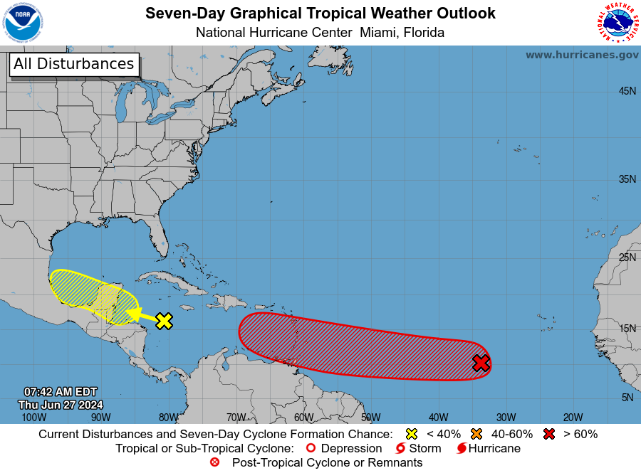
Forecasters estimate 70 percent odds that the disturbance, currently midway between South America and Africa, will intensify into a tropical depression or storm. Weather models are bullish on its long-term prospects, with some even suggesting it could strengthen into a hurricane as it slowly slides west toward the Caribbean.
Another system, located in the western Caribbean, will probably bring some wet and squally weather to Mexico’s Yucatán Peninsula over the weekend.
It’s still early in 2024′s Atlantic hurricane season, which historically doesn’t peak until mid-September on average. Forecasters are concerned that anomalously warm water temperatures, along with relaxed high-altitude winds stemming from a burgeoning La Niña pattern, could favor an exceptionally active season.
What to know about the system that could intensify this weekend
The more notable of the two systems currently exists several hundred miles southwest of the Cabo Verde islands in the Atlantic, midway between French Guiana in South America and Sierra Leone in Africa.
The Hurricane Center pegs its probability of development at 70 percent and writes that “a tropical depression or tropical storm is likely to form this weekend several hundred miles east of the Windward Islands.” The system is moving west at 15 to 20 mph.
On infrared satellite, roiling thunderstorms can be seen billowing and blossoming. Already, a scatterometer, or a sensor aboard a satellite that derives wind speeds, suggested the storm has 35 mph winds. That’s just below tropical storm force. It doesn’t have a center yet, so it isn’t at risk of becoming a named storm yet today.
Weather models indicate gradual, but steady, organization and intensification of the system in the days ahead. There are two mitigating factors slowing its expected strengthening:
- The Saharan Layer (SAL), or dust trapped in a layer of hot, dry air about a mile above the ground. That layer suppresses warm, moist air below and prevents air pockets from rising vertically and forming thunderstorms. Invest 95L is south of the Saharan Air Layer, but the SAL may pump the brakes on swifter organization.
- Shear, or changing winds with height. Shear across the Central Atlantic tends to be an obstacle for storms this time of year in the Atlantic’s MDR, or Main Development Region. (That’s the imaginary box across the central tropical Atlantic within which many long-track hurricanes form). Shear does look to relax in the days ahead, but models oftentimes underestimate how much shear is present in the Central Atlantic. Subsequently, Invest 95L may not strengthen more aggressively until it approaches the Windward Islands late Sunday.
Once it reaches the Lesser Antilles, however, it could strengthen into a hurricane. That’s when ingredients will become more favorable for a strengthening storm — and anything in the Caribbean bears watching for eventual land impacts.
The second system to watch
A batch of showers and thunderstorms was present in the western Caribbean east of Nicaragua and Honduras. Convection, or shower and thunderstorm activity, was vigorous. That said, there was no discernible circulation.
A belt of strong mid-level winds currently draped over the Caribbean will inhibit its chances of organizing. Ironically, tropical disturbances require nearly calm winds at multiple levels of the atmosphere to consolidate. Too much wind will knock any nascent disturbance off-kilter, spelling its early demise.
The National Hurricane Center has designated this disturbance “Invest 94L” and estimates it has a 30 percent chance of eventual maturation.
It will probably pass near Cancún on Saturday and the Bay of Campeche on Sunday, bringing scattered heavy downpours. Thereafter, it will quickly fall apart.
#tropical #storm #form #Atlantic #weekend,
#tropical #storm #form #Atlantic #weekend
