Chances for tropical cyclone development increase in Atlantic basin
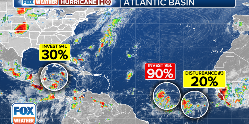
The FOX Forecast Center is monitoring two areas of disturbed weather in the Atlantic basin for development over the next week. None pose an immediate threat to the U.S.
A new tropical disturbance is now being monitored for development in the eastern Atlantic Ocean just in the wake of Invest 95L, which is on the cusp of becoming a tropical depression or Tropical Storm Beryl.
The new disturbance is just a few hundred miles south-southwest of the Cabo Verde Islands and is as of now just producing disorganized showers and thunderstorms. However, some slow development of this system is possible early next week while it moves generally westward across the central and western tropical Atlantic at 15 to 20 mph, according to the National Hurricane Center (NHC). It currently has a 20% chance of development within the next week.
But it’s the sister storm just to its west that is currently garnering the most attention in the tropics.
Computer forecast models show tropical development is likely as that disturbance, dubbed Invest 95L by the NHC, approaches the Caribbean islands late Sunday or Monday. An invest is a naming convention used by the NHC to identify areas it is investigating for possible tropical development within the next week.
However, the FOX Forecast Center said there is considerable uncertainty about where the system will go after that time and how strong it could become.
The NHC now has the development chances for Invest 95L in the high range. Those odds are for the development of at least a tropical depression.
“(Wednesday), a number of the computer simulations showed the system developing into a hurricane next week,” FOX Weather Hurricane Specialist Bryan Norcross said. “(Thursday), the various computer models mostly show a weaker system heading west. If the storm ends up in the Caribbean, which is the consensus, it would be pretty unusual for the system to strengthen, although it has happened.”
For now, there is nothing to do but stay informed, especially in the Caribbean islands, Norcross added.
BRYAN NORCROSS: UNUSUAL JUNE DEVELOPMENT IN THE TROPICAL ATLANTIC IS LOOKING MORE LIKELY
Before 2021, it was rare for a June tropical storm to develop in the Atlantic east of the Caribbean. In the last three years, however, it’s happened three times, and Bonnie tried hard in 2022 but didn’t get going until it reached the western Caribbean.
Invest 94L
Another disturbance dubbed Invest 94L is moving through the Caribbean toward Central America and southern Mexico, bringing the possibility of heavy and dangerous rainfall.
The NHC is giving this system a low chance of developing. If it does, it would likely be in the far western Caribbean or the extreme southern Gulf of Mexico, if the system survives its trek across land, Norcross said.
“On the current schedule, the disturbance will impact Central America and move into the southern Gulf over the weekend,” he explained. “High pressure across the southern U.S. should keep the system well to the south.”
#tropical #wave #sits #Atlantic #potential #Tropical #Storm #Beryl #looms #nearby,
#tropical #wave #sits #Atlantic #potential #Tropical #Storm #Beryl #looms #nearby
