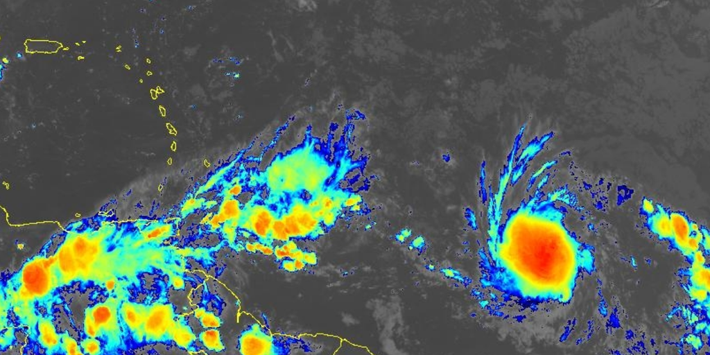
Strengthening Tropical Storm Beryl becoming a hurricane threat to Windward Islands
Our second named storm of the season, Tropical Storm Beryl, has formed. The Windward Islands, specifically Barbados and Grenada, should be on high alert for a hurricane.
Tropical Storm Beryl is quickly gathering steam in the central Atlantic with at least one island nation in the Caribbean now under a Hurricane Watch.
The National Hurricane Center (NHC) has been tracking this system, formerly known as Tropical Depression Two, for development over the last few days. Satellite imagery on Friday indicated the system had gained enough organization to be classified as a tropical storm and is expected to become a hurricane by Saturday night or Sunday.
At last report from the NHC, the cyclone had maximum sustained winds of at least 50 mph. The cyclone will be classified as a hurricane once sustained wind speeds reach at least 74 mph.
Beryl is expected to become the first hurricane of the 2024 season, a statistic that usually isn’t reached until Aug. 11.
2024 ATLANTIC HURRICANE SEASON GUIDE: HERE’S WHAT TO KNOW ABOUT THIS YEAR’S STORMS
Where is Tropical Storm Beryl?
Tropical Storm Beryl is located in the tropical Atlantic less than 1,000 miles east-southeast of the Windward Islands and is not a direct threat to any landmasses during the next 24 hours.
On its current trajectory, the cyclone is expected to impact southern parts of the Windward Islands on Monday.
WHERE ARE THE LESSER ANTILLES, WINDWARD ISLANDS AND LEEWARD ISLANDS
BERYL TRACKER: LIVE FORECAST, TROPICAL WEATHER ALERTS, SPAGHETTI MODELS AND MORE
What is the forecast for Tropical Storm Beryl?
Tropical Storm Beryl is expected to continue strengthening and soon become a hurricane before impacting the Caribbean.
A Hurricane Watch has been issued for Barbados with additional watches and warnings likely coming for the Windward Islands later Saturday.
On its forecast trajectory, islands such as Barbados, Grenada, Saint Lucia, Martinque and Saint Vincent and the Grenadines will receive direct impacts from the storm.
Tropical storm-force winds are likely along the affected islands by Sunday with hurricane-force winds likely Sunday night or Monday morning, according to the NHC.
Forecast models show winds reaching upwards of 100 mph as the cyclone moves through some of the islands and potentially maxing out at nearly a Category 3 on the Saffir-Simpson Scale while south of Puerto Rico.
“Typically, the atmospheric environment is unfavorable for intensification in this portion of the Atlantic basin in late June. However, the overall atmospheric and oceanic conditions appear conducive for steady strengthening during the next few days,” NHC forecasters stated.
In addition to hurricane-force winds, torrential rains will drench the islands. Current forecast totals predict Beryl will bring 3-6 inches of rain across Barbados and the affected Windward Islands, producing localized flooding.
Heavy swells from Beryl are likely to create life-threatening surf and rip currents along the island chain.
Will Beryl impact the U.S.?
The closest American territories to the storm are the U.S. Virgin Islands and Puerto Rico, and neither is under a watch.
The FOX Forecast Center expects the main impacts to remain south of the islands; however, a passing band of showers cannot be ruled out.
It is too soon to tell if the hurricane will ever threaten the continental U.S., but if it does, it will likely be in a different form.
“For now, high pressure over the southeastern US appears most likely to hold Beryl well to the south, at least well into the Caribbean,” said FOX Weather Hurricane Specialist Bryan Norcross. “But it’s too early to be sure of the long term. Forecasts for systems that have yet to develop or are just organizing intrinsically have much larger errors than those for well-developed storms.”
WHY THE EASTERN CARIBBEAN IS KNOWN AS THE ‘HURRICANE GRAVEYARD’
Tracking disturbance east of Beryl & Invest 94L around Central America.
A disturbance a couple of hundred miles east of Beryl is producing disorganized showers and thunderstorms.
Some slow development of this system is possible early next week as it moves generally westward across the central and western tropical Atlantic at 15 to 20 mph, according to the NHC.
It currently has a medium chance of development over the next week and could take a similar track as Beryl.
Another disturbance dubbed Invest 94L is moving through the Caribbean toward Central America and southern Mexico, bringing heavy rainfall.
The NHC is giving this system a medium chance of developing. If it does, Norcross said it would likely be in the far western Caribbean or the extreme southern Gulf of Mexico if the system survives its trek across land.
“On the current schedule, the disturbance will impact Central America and move into the southern Gulf over the weekend,” Norcross explained. “High pressure across the southern U.S. should keep the system well to the south.”
#Hurricane #Watch #issued #Tropical #Storm #Beryl #charges #Caribbean,
#Hurricane #Watch #issued #Tropical #Storm #Beryl #charges #Caribbean
