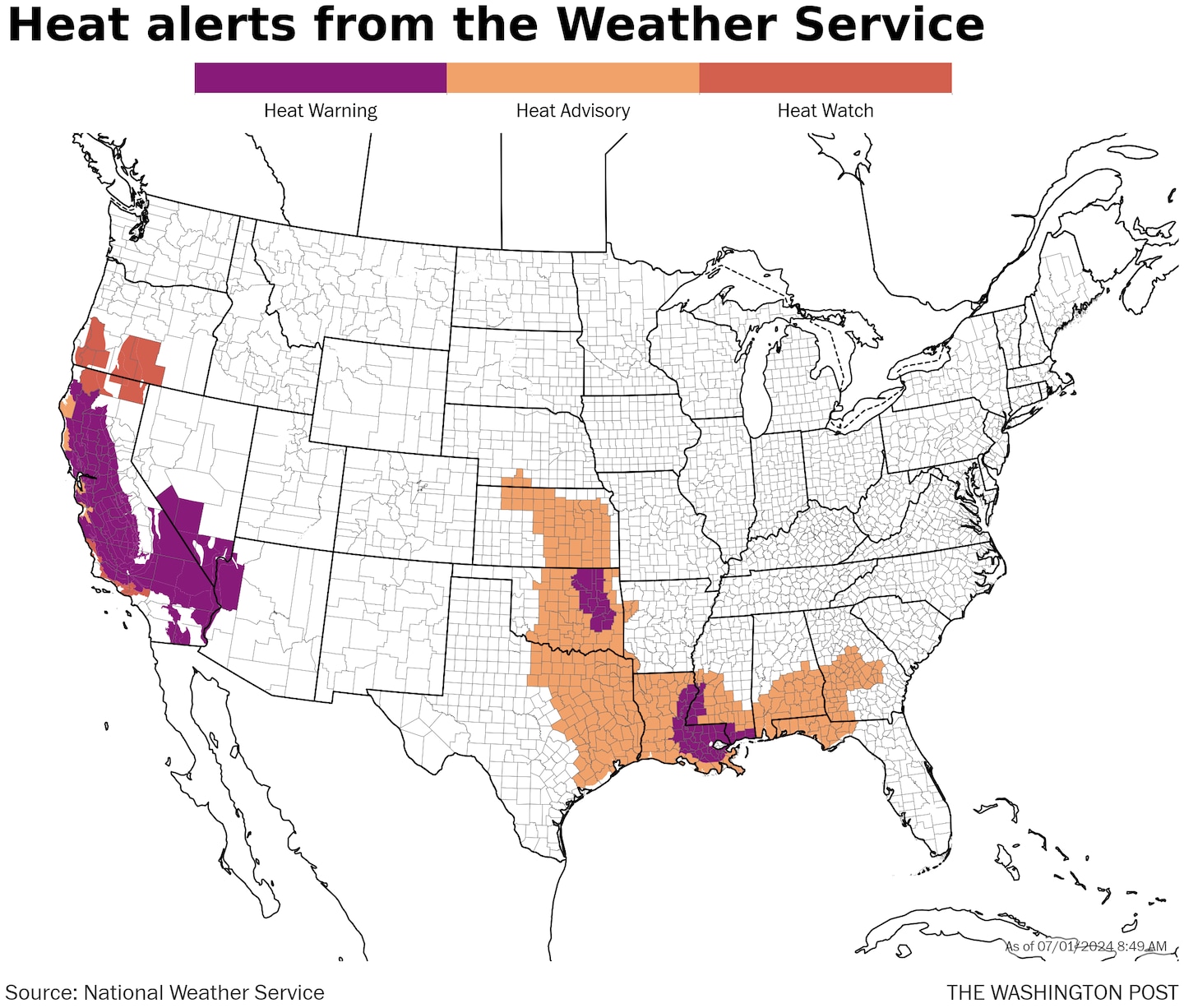
The National Weather Service office in Hanford, which serves much of California’s Central Valley, is warning of a “dangerous, prolonged heat wave that will last several days with Extreme Heat Risk through this week of Fourth of July.”
Heat advisories run from eastern Kansas to East Texas, then across the northern Gulf Coast region through southern Georgia and the Florida Panhandle. Oklahoma City; Dallas; Houston; Mobile, Ala.; and Tallahassee are in the heat advisory area, generally for heat indexes up to 110 degrees.
At least 45 million Americans are likely to be subjected to actual high temperatures at or above 100 degrees this week. Over two-thirds of the population will experience 90 degrees, often on many days.
That new HeatRisk product forecasts a Level 4 of 4 extreme threat to affect at least 14 states through the next seven days. About two dozen states have significant coverage of a Level 3 of 4 major threat.
Where the heat is most intense to start the week
Typically sultry New Orleans basks in drippy distress Monday. Heat indexes of 112 to 118 will be common, according to the local Weather Service office. Actual temperatures will reach the mid-90s. Heat indexes around 115 are anticipated in Tulsa and surrounding areas.
A long, punishing and dangerous heat spell is also revving up Monday in California. Temperatures should end up near 100 for highs in the Central Valley, with 100 to 110 common in desert areas to the south.
Even areas typically cooled by the ocean may feel the heat. That’s because of a stunted marine layer of clouds and fog due to the heat dome overhead.
In parts of the west — California and the Great Basin in particular — fire weather will also be of concern. Red flag warnings are up in sections of central California and southwestern Utah. Several large fires are burning amid a fast start to the season in these regions.
In portions of Kansas through Oklahoma and into Texas on Monday and Tuesday, temperatures of at least 100 degrees will also be widespread. Heat gets kicked farther south mid- and late week, while somewhat below-average temperatures settle into the central Plains by the end of the week, probably only for a short time.
The hot spots in coming days
Heat will be building in much of the eastern United States heading into the holiday period. Independence Day looks like a scorcher from the Mid-Atlantic through the Southeast and back to Texas. A majority of spots shoot for the mid- or upper 90s with higher heat indexes.
It should stay similar in these regions into the weekend, with perhaps an occasional decrease in day-to-day temperatures outside the Southeast, in part due to potentially heightened rain risks.
By the Fourth of July, highs near 110 likely remain common in the Central Valley of California, the deserts of that state and into neighboring Arizona as well as southern Nevada.
“Far inland areas may actually end up with triple digits into the weekend and the start of the next week,” wrote the Weather Service office serving the San Francisco Bay Area.
Little change is expected through the weekend. Temperatures may rise toward 90 as far north as the Seattle region, with 100-plus forecast for eastern Washington state.
Record temperatures ahead
It was the hottest June on record in many places, such as the intermountain west, South Texas and parts of New England. Some broad areas surrounding those locations witnessed one of their top-five hottest Junes.
July is primed to keep going. Hundreds of daily record highs and record warm lows are on the chopping block this week, from coast to coast.
A handful of record highs are possible each day early in the week, and by Thursday through Sunday, numerous daily records could fall. Potential record heat is overwhelmingly clustered in California and parts of neighboring states, though records will also be possible in the central and eastern United States at times.
“A few climate sites may flirt with all-time temperature records,” wrote the Weather Service office serving the Las Vegas area, where temperatures are forecast to rise to about 115, with lows near 90 late week.
Notable targets include Redding in Northern California around 115, much of the Central Valley near 110 for days on end, Las Vegas on multiple days around 115 and the coastal Southeast occasionally near 100.
Death Valley — one of the hottest places on earth — is staring down an evil week of weather and has a chance to flirt with the highest temperature recorded by modern instrumentation.
Forecast highs there from Monday through Sunday are: 118, 122, 125, 127, 128, 128 and 129. The hottest temperature observed there is 134, although there are questions about its reliability. In 2020 and 2021, Death Valley reached 130 degrees, the highest reliably observed temperature on record. It also reached 129 in 2023.
Considerably more impressive in coverage, there may be dozens of daily record warm lows, maybe rising to more than 100 of them on several days through the weekend. Phoenix, for one, will experience 90-plus lows, while many other locations remain at or above 80. Record warm nights are a leading symptom of human-caused climate change and a major magnifier of danger from heat waves.
#Heres #heat #intense #U.S #July #begins,
#Heres #heat #intense #U.S #July #begins
