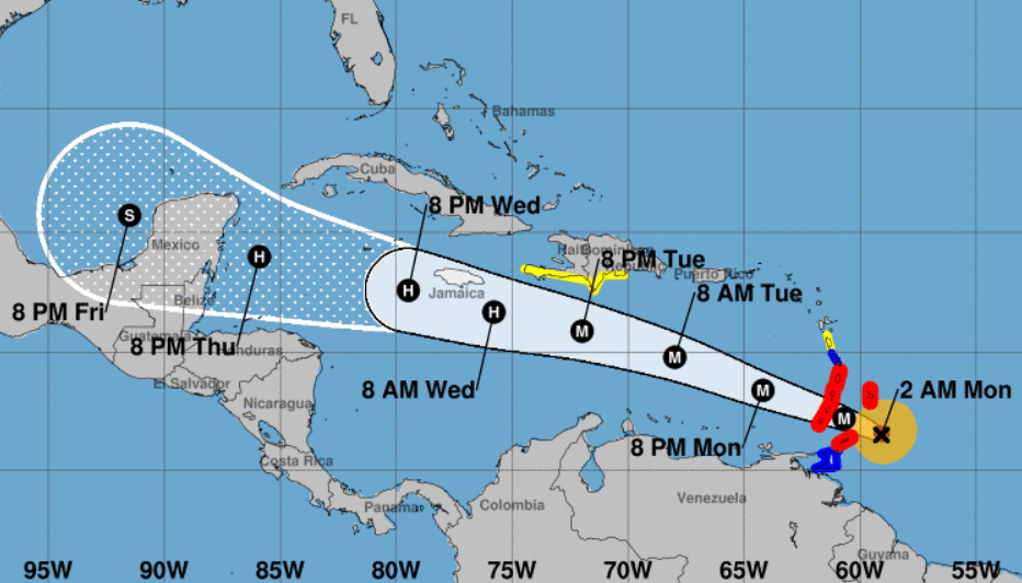
Hurricane Beryl, which became the season’s first major hurricane on Sunday, reaching Category 4 strength, saw its intensity tick down to 120 mph early Monday morning, making it a Category 3 storm as it approached the Caribbean.
Still, Beryl is packing “life-threatening winds and storm surge” of as much as 6 to 9 feet and 3 to 6 inches of rain across Barbados and the Windward Islands on its approach to the far eastern Caribbean early Monday, according to the National Hurricane Center.
It is forecast to maintain its major-hurricane status as it sweeps into the Caribbean Sea.
Jamaica, Belize and parts of Mexico were within Beryl’s cone Sunday.
At 2 a.m. Monday, Hurricane Beryl was 110 miles south-southeast of Barbados and 165 miles east-southeast of Grenada, moving west at 20 mph.
Hurricane-force winds extend outward up to 30 miles from Beryl’s center and tropical-storm-force winds extend outward up to 115 miles.
A hurricane warning is in effect for Barbados, St. Lucia, St. Vincent, Tobago, and the Grenadine Islands and Grenada, while a tropical storm warning is in effect for Martinique. A tropical storm watch is in effect for Dominica, Trinidad, the Dominican Republic from Punta Palenque westward to the border with Haiti and the entire south coast of Haiti from the border of the Dominican Republic to Anse d’Hainault.
“Development this far east in late June is unusual,” the forecasters at the hurricane center said. “In fact, there have only been a few storms in history that have formed over the central or eastern tropical Atlantic this early in the year.”
Beryl is expected to remain a significant hurricane through the next five days, forecasters said Sunday, though it is not expected to affect South Florida.

Meanwhile, Tropical Storm Chris was 75 miles southeast of Tuxpan, Mexico on Monday at the 2 a.m. advisory and beginning to move inland.
Forecasters also said that a tropical wave in the eastern Atlantic off Africa could become a tropical depression by midweek as it moves toward the eastern and central Caribbean.

It has a 40% chance of developing in the next two days and a 70% chance in the next seven days.
It is expected to move west at 15 to 20 mph, forecasters said.
The next storm to form would be Debby.
The western Gulf of Mexico generated the 2024 season’s first tropical storm last week. Dubbed Alberto, the system made landfall in Mexico 250 miles south of the U.S. border, but sent storm surge and flood to spots 500 miles away in Louisiana.
The 2024 hurricane season, which officially began June 1, is expected to be extremely active.
In its annual May outlook, the National Oceanic and Atmospheric Administration said that the 2024 hurricane season has an 85% chance of being above normal, with 17 to 25 named storms with minimum sustained winds of 39 mph, and eight to 13 hurricanes. An average year has 14 named storms and seven hurricanes.
In addition, NOAA has forecast four to seven major hurricanes for 2024, meaning those that are Category 3 or above.
Experts at Colorado State University stated in their 2024 forecast that the U.S. East Coast, including Florida, had a 34% chance of a major hurricane making landfall this year. The average from 1880-2020 was 21%.
Forecasters say that the record-warm water temperatures that now cover much of the Atlantic Ocean will continue into peak hurricane season from August to October. That warm water fuels hurricanes. By early June, the tropical Atlantic was already as hot as it usually is in mid-August — peak hurricane season.
Hurricane season officially ends Nov. 30.
#Hurricane #Beryl #bearing #Barbados #Category #storm #Jamaica #path #Tropical #Storm #Chris #starts #moving #Mexico,
#Hurricane #Beryl #bearing #Barbados #Category #storm #Jamaica #path #Tropical #Storm #Chris #starts #moving #Mexico
