A tropical disturbance over the central Atlantic Ocean is expected to move west towards Florida, according to the National Hurricane Center.In its Sunday morning advisory, the NHC predicted that the tropical disturbance would interact with an approaching tropical wave during the next several days.”Environmental conditions are forecast to become conducive for some development in a day or two, and a tropical depression could form around midweek while the system is near or over the northern Leeward Islands, Greater Antilles, or southwestern Atlantic Ocean,” the NHC said. According to the NHC, the formation chances are zero percent in the next two days and 40% in the next seven days. It is too early to speculate exactly where it may be headed, but the WESH 2 First Warning meteorologists are monitoring the system. Meteorologist Eric Burris says it’s “definitely one to watch.”Meteorologist Eric Burris takes a look at the latest models in the video below:Related: Surviving the Season | 2024 Hurricane Special from WESH 2More: Where do hurricanes begin?First Warning WeatherStay with WESH 2 online and on-air for the most accurate Central Florida weather forecast.RadarSevere Weather AlertsDownload the WESH 2 News app to get the most up-to-date weather alerts.The First Warning Weather team includes First Warning Chief Meteorologist Tony Mainolfi, Eric Burris, Kellianne Klass, Marquise Meda and Cam Tran.
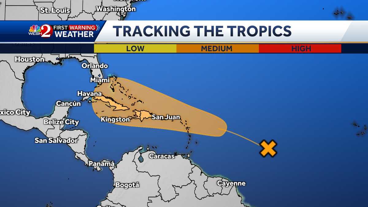
A tropical disturbance over the central Atlantic Ocean is expected to move west towards Florida, according to the National Hurricane Center.
In its Sunday morning advisory, the NHC predicted that the tropical disturbance would interact with an approaching tropical wave during the next several days.
“Environmental conditions are forecast to become conducive for some development in a day or two, and a tropical depression could form around midweek while the system is near or over the northern Leeward Islands, Greater Antilles, or southwestern Atlantic Ocean,” the NHC said.
According to the NHC, the formation chances are zero percent in the next two days and 40% in the next seven days.
It is too early to speculate exactly where it may be headed, but the WESH 2 First Warning meteorologists are monitoring the system. Meteorologist Eric Burris says it’s “definitely one to watch.”
This content is imported from Twitter.
You may be able to find the same content in another format, or you may be able to find more information, at their web site.
Meteorologist Eric Burris takes a look at the latest models in the video below:
This content is imported from Twitter.
You may be able to find the same content in another format, or you may be able to find more information, at their web site.
Related: Surviving the Season | 2024 Hurricane Special from WESH 2
More: Where do hurricanes begin?
First Warning Weather
Stay with WESH 2 online and on-air for the most accurate Central Florida weather forecast.
Download the WESH 2 News app to get the most up-to-date weather alerts.
The First Warning Weather team includes First Warning Chief Meteorologist Tony Mainolfi, Eric Burris, Kellianne Klass, Marquise Meda and Cam Tran.
#Disturbance #moves #west #Florida,
#Disturbance #moves #west #Florida
