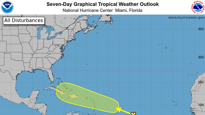
Weeks after Hurricane Beryl caused devastating damage in the Caribbean and knocked out power to millions in southeast Texas, a new disturbance is brewing in the tropics. The National Hurricane Center is tracking a system in the central Atlantic that shows signs it could develop momentum.
Plumes of dust – made up of sand and particle minerals – from Africa’s Sahara Desert and extremely dry air have hindered thunderstorm activity and tropical cyclone formation in the Atlantic over the last month, according to meteorologists. However, activity is expected to pick up at the end of July and early August as the dry and dusty air diminishes and ocean temperatures continue to rise.
“Especially with La Niña starting to develop we’re going to be seeing a lot more tropical systems developing here,” AccuWeather Senior Meteorologist Alan Reppert told USA TODAY on Sunday. “We did predict that there would be at least some break here until the early part of August when we start to see more chances and more threats for development.”
Over the weekend, the National Hurricane Center reported an “area of disturbed weather” over the central Atlantic Ocean that is forecast to interact with an approaching tropical wave during the next couple of days. By Sunday morning, officials said the system had a 40% chance of development over the next seven days.
The disturbance is predicted to develop within the next day or two and a tropical depression could form mid-to-late week while the system is near or over the northern Leeward Islands, Greater Antilles, or the southwestern Atlantic Ocean, according to the National Hurricane Center.
The system comes about two weeks after a lull in tropical activity in the Atlantic. The 2024 Atlantic hurricane season began with an “explosive start” when Beryl made landfall on Carriacou Island on July 1 as a Category 4 hurricane before it weakened to a Category 1 and slammed the Texas coast the following week, according to the National Oceanic and Atmospheric Administration or NOAA.
Dry, dusty air could stop tropical development
AccuWeather meteorologists said the area of low pressure that recently moved off the coast of Africa has the potential for development in August. However, the chances of a system forming over the next 48 hours remain low – nearly 0% – the National Hurricane Center said.
“There is some dry and dusty air that is over much of the Atlantic that could stop the development of this,” Reppert said. “This system is still well east of the Leeward Islands so it still has several hundred miles until it even approaches where we’re expecting this to at least try to develop.”
Dr. Jill Trepanier, associate professor in the Department of Geography and Anthropology at Louisiana State University, noted that tropical development in the earliest stages of the hurricane season is “somewhat sporadic.” The Atlantic hurricane season runs from June 1 through Nov. 30.
“The August-September zone of the Atlantic season is the most active period,” Trepanier told USA TODAY. “We’re kind of moving into that space where it’s most likely, out of the entire time, for us to see more of them develop.”
At the moment, Trepanier said the disturbance in the central Atlantic is a small cluster of thunderstorms that could organize into a system. If the system pushes through the hostile conditions, it may face “more favorable conditions” for tropical development in August, said Bernie Rayno, AccuWeather’s chief on-air meteorologist.
Dangerous hurricane season
Forecasters have warned they’re anticipating a dangerous hurricane season, and that’s still their mindset. Despite the brief period of quiet after Beryl, the 2024 Atlantic hurricane season is still expected to be extremely active.
Beryl broke records, rapidly strengthening to the earliest Category 5 hurricane on record. After it made landfall on the Texas coast, forecasters from Colorado State University raised their hurricane forecast to a total of 12 hurricanes and 25 storms for the season.
“Hurricane Beryl, a deep tropical Category 5 hurricane, is also a likely harbinger of a hyperactive season,” the updated forecast says.
In May, the NOAA predicted an 85% chance of an above-normal season. The agency forecasted 17 to 25 total named storms with eight to 13 becoming hurricanes.
The hyperactive season is due to a confluence of factors, the agency says, including warmer-than-normal water temperatures in the Atlantic, development of La Niña conditions in the Pacific, and reduced trade winds and wind shear in the Atlantic.
USA TODAY previously reported that oceans have been breaking daily heat records since early 2023 and experts have called water temperatures in the Atlantic “absolutely stunning.”
Contributing: Cheryl McCloud and Jennifer Sangalang, USA TODAY NETWORK – Florida
#Tropical #disturbance #brewing #Atlantic #hurricane #season,
#Tropical #disturbance #brewing #Atlantic #hurricane #season

