Live in player above: WESH 2 Meteorologist Eric Burris talks large tropical wave on path toward Florida A large tropical wave moving west toward Florida has once again increased in formation chances and could become a tropical depression this week, the National Hurricane Center says.According to the NHC, the tropical wave is currently centered several hundred miles east of the Lesser Antilles and is producing some shower activity, but not a lot, due to dry air aloft.Though the system has to fight things like dry air and Saharan dust, the NHC says environmental conditions are expected to become more conducive for development as that storm moves into warmer waters in the next few days.Mid-to-late week, the system could form into a tropical depression in the vicinity of the Greater Antilles or the Bahamas, the NHC said.It is too early to speculate exactly where it may be headed, but the WESH 2 First Warning meteorologists are monitoring the system. The NHC said this is especially important for those in the Greater Antilles, the Bahamas and the southeastern United States.The window for development is still days away, and once the system develops — if at all — officials will be able to know more.Strong storms that develop quickly tend to curve into the Atlantic, while slow-developing systems tend to move more into the Gulf of Mexico. It is still too far out for models to run clear, concise paths.Video below: First Warning Meteorologist Kellianne Klass compares two model runs on the system, which are both starting to trend west. According to the NHC, formation chances are near 0% for the next 48 hours but jump to 60% in the next seven days.Related: Surviving the Season | 2024 Hurricane Special from WESH 2More: Where do hurricanes begin?First Warning WeatherStay with WESH 2 online and on-air for the most accurate Central Florida weather forecast.RadarSevere Weather AlertsDownload the WESH 2 News app to get the most up-to-date weather alerts.The First Warning Weather team includes First Warning Chief Meteorologist Tony Mainolfi, Eric Burris, Kellianne Klass, Marquise Meda and Cam Tran.
Live in player above: WESH 2 Meteorologist Eric Burris talks large tropical wave on path toward Florida
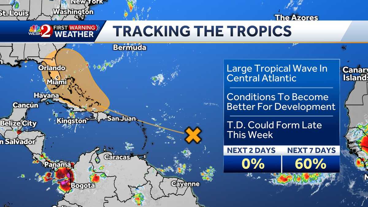
A large tropical wave moving west toward Florida has once again increased in formation chances and could become a tropical depression this week, the National Hurricane Center says.
According to the NHC, the tropical wave is currently centered several hundred miles east of the Lesser Antilles and is producing some shower activity, but not a lot, due to dry air aloft.
Though the system has to fight things like dry air and Saharan dust, the NHC says environmental conditions are expected to become more conducive for development as that storm moves into warmer waters in the next few days.
Mid-to-late week, the system could form into a tropical depression in the vicinity of the Greater Antilles or the Bahamas, the NHC said.
This content is imported from Twitter.
You may be able to find the same content in another format, or you may be able to find more information, at their web site.
This content is imported from Twitter.
You may be able to find the same content in another format, or you may be able to find more information, at their web site.
It is too early to speculate exactly where it may be headed, but the WESH 2 First Warning meteorologists are monitoring the system. The NHC said this is especially important for those in the Greater Antilles, the Bahamas and the southeastern United States.
The window for development is still days away, and once the system develops — if at all — officials will be able to know more.
Strong storms that develop quickly tend to curve into the Atlantic, while slow-developing systems tend to move more into the Gulf of Mexico. It is still too far out for models to run clear, concise paths.
Video below: First Warning Meteorologist Kellianne Klass compares two model runs on the system, which are both starting to trend west.
According to the NHC, formation chances are near 0% for the next 48 hours but jump to 60% in the next seven days.
Related: Surviving the Season | 2024 Hurricane Special from WESH 2
More: Where do hurricanes begin?
First Warning Weather
Stay with WESH 2 online and on-air for the most accurate Central Florida weather forecast.
Download the WESH 2 News app to get the most up-to-date weather alerts.
The First Warning Weather team includes First Warning Chief Meteorologist Tony Mainolfi, Eric Burris, Kellianne Klass, Marquise Meda and Cam Tran.
#model #runs #disturbance #moving #Florida,
#model #runs #disturbance #moving #Florida
