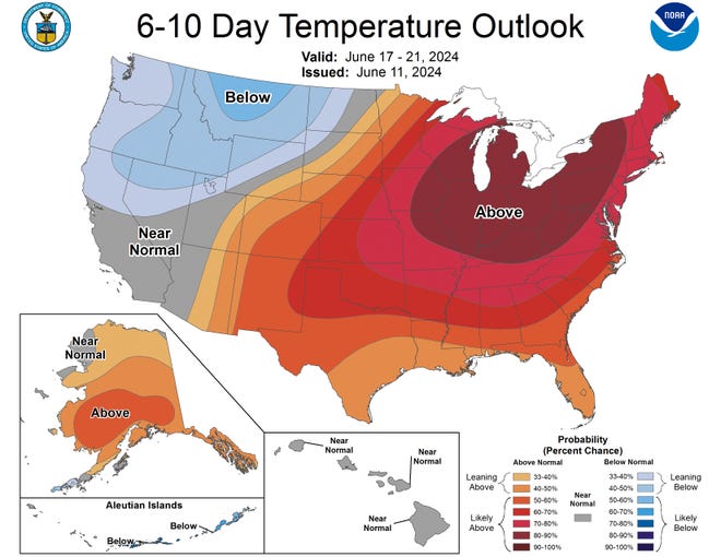
A heat wave is expected to expand from the central Plains into the eastern U.S. on Monday and remain across the Northeast through at least midweek as a winter storm drops snow on Montana and Idaho, according to the National Weather Service.
As of 8 a.m. ET Monday, over 59 million people in the U.S. were under heat advisories, with over 5 million being under an excessive heat warning and over 16 million being under an excessive heat watch.
The National Weather Service’s Heat Risk map for Monday shows a broad splash of red, indicating major heat, reaching from West Virginia to Kansas. The heat danger was up to purple in parts of Iowa, Illinois and Missouri, indicating extreme heat with little to no temperature relief overnights and potential impacts on heat-sensitive industries and infrastructure, the NWS notes.

Tom Kines, a meteorologist with Accuweather, expects in the heat in the central and eastern part of the country to be a headline this week.
“The Midwest, the Ohio Valley, the Great Lakes, the mid-Atlantic and the Northeast – this will be the first 90-degree temperatures a lot of these places have gotten so far this year,” he told USA TODAY Sunday.
The week ahead in weather:Crazy weather week coming to the US: From searing heat to snow. Yes, snow.

Snow expected in northern Rockies amid winter storm warnings
As the Midwest sizzles, areas farther west are expected to freeze.
Parts of the northern Rocky Mountains could see temperatures dip down to the 20s. After winter storm warnings were issued for western Montana and eastern Idaho on Sunday, the area could see snow as the week begins.
Forecasters warned of possible power outages caused by “heavy, wet snow” that could also down trees, while unpaved roads could become treacherous, according to the National Weather Service in Missoula, Montana.
By Monday morning snow had already blanketed high elevation parts of the area, including the 7,000-foot Lost Trail Pass, which runs along the Montana-Idaho border, according to pictures shared by the weather service on X.
The summer storm could pile on more than a foot of snow in some areas, making travel through mountain passes “slippery” and “difficult” Monday evening through Tuesday, according to AccuWeather forecasters.
Severe thunderstorm watches issued in Iowa, Minnesota, Wisconsin on Monday
While large parts of the country are under heat advisories, over 1 million people are under severe thunderstorm watches Monday.
According to the NWS, heavy rain and severe thunderstorms are possible Monday across the north-central Plains, shifting north into the northern Plains and northern Minnesota late Monday night into Tuesday.
The thunderstorms are expected to shift farther south from the central Plains to the upper Midwest on Tuesday night into Wednesday morning, according to the NWS.
National weather watches and warnings
Gabe Hauari is a national trending news reporter at USA TODAY. You can follow him on X @GabeHauari or email him at Gdhauari@gannett.com.
#Midwest #heat #advisories #snow #hits #Rockies,
#Midwest #heat #advisories #snow #hits #Rockies
