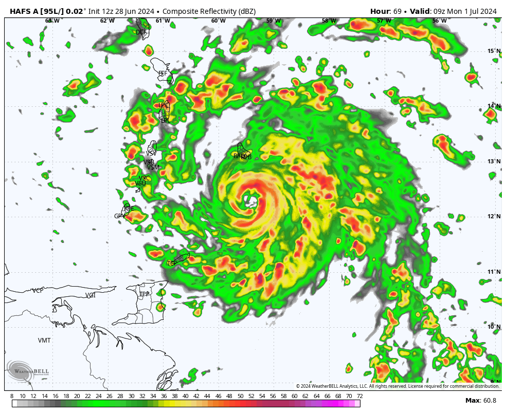
Beryl was located a little more than 1,100 miles east-southeast of the Windward Islands and is drifting west. Conditions favor steady strengthening of the system, and rapid intensification can’t be ruled out. Those around the Caribbean should keep close tabs on the storm’s progress through the middle of next week.
Meanwhile, there are two other disturbances in the Atlantic, each with 30 percent odds of eventual development. One is a robust tropical wave rolling off the coast of Africa, and the other is in the western Caribbean and is soon to soak the Yucatán Peninsula with heavy rains.
It’s only June, but the Atlantic is exhibiting mature development over the Main Development Region, or the imaginary box of oceanic real estate between South America and Africa in the tropical Atlantic. That’s more typical of late July or August. Experts are calling for this hurricane season to be particularly busy or even hyperactive, owing to anomalously warm sea-surface temperatures and supportive upper-level winds tied to a burgeoning La Niña pattern.
As of 11 p.m. Eastern time Friday, Beryl was located 1,110 miles east-southeast of Barbados. It was moving west at 18 mph. Maximum sustained winds were listed at 40 mph.
Tropical storm or hurricane watches could be needed as early as Saturday morning for portions of the Windward Islands and Lesser Antilles.
The National Hurricane Center wrote that “Tropical Storm Beryl is one of only a few storms in history that have formed over the central or eastern tropical Atlantic this early in the year.”
The system has robust convection, or shower and thunderstorm activity. More of this thunderstorm activity is blossoming to the west of the low-level center, but it’s probable that Beryl will become more symmetric and vertically aligned in the next day or so.
It also has healthy outflow, or cool air exhaust at the upper levels. That was evident in the thin, wispy cirrus clouds fanning out from the center. That shows the storm is breathing — inhaling warm, moist air from below and evacuating “spent” air from above. That’s a sign of a well-organized disturbance.
A dome of high pressure over the central Atlantic will act as a force field of sorts, suppressing the system south and preventing it from “recurving,” or escaping to the north. Because highs spin clockwise, the incipient storm will continue almost due west. That will take it toward the Lesser Antilles by Monday.
Strong upper-level winds can tear apart a fledgling system, but Beryl’s southerly path means it will escape the majority of hostile high-altitude winds to the north.
Beryl will also stay south of the Saharan Air Layer — a lid of hot, dry desert air and dust about a mile or two above the ground. That dry air can erode a developing storm’s circulation, but that won’t happen here.
Through Monday, the storm will strengthen, likely into a hurricane, as it extracts energy from the warm waters of the tropical Atlantic. The National Hurricane Center is explicitly forecasting a high-end Category 1 or low-end Category 2 by then, with winds of 90 to 105 mph within the core of the storm. It will impact the Windward or Leeward Islands. A general 3 to 6 inches of rain is expected, too.
Thereafter, Beryl will continue into the Caribbean. It’s unclear if any land interaction will cut back on Beryl’s strength by Tuesday or Wednesday. Still, those in Jamaica, Cuba and Hispaniola should closely monitor the storm’s progress.
There are two other disturbances worth keeping an eye on in the Atlantic. One in the northwestern Caribbean is organizing some, but it may lose that organization as it moves inland over the Yucatán Peninsula over the next 48 hours. Thereafter, it may try to regain some strength in the Bay of Campeche into early next week. Heavy rains and flooding are possible, with 4 to 8 inches of rain in extreme northern Belize and Guatemala and the Yucatán.
Otherwise, another tropical wave over Africa appears ready to develop during its long trek across the Atlantic.
#Tropical #Storm #Beryl #forms #enter #Caribbean #Category #hurricane,
#Tropical #Storm #Beryl #forms #enter #Caribbean #Category #hurricane
