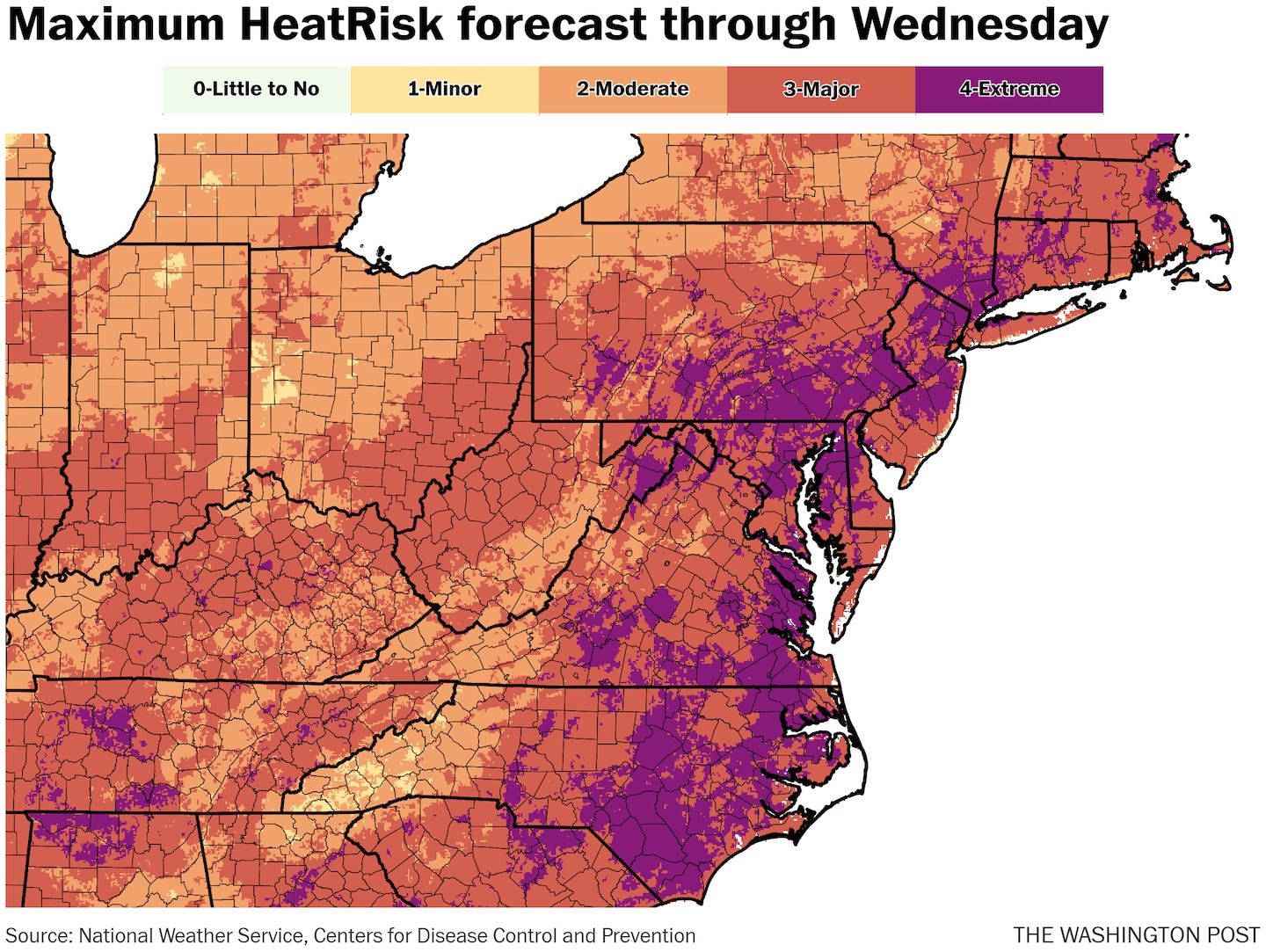
Washington, Baltimore, Philadelphia and much of eastern North Carolina and Southeast Virginia are under excessive-heat warnings, the highest level alert. In these areas, highs are expected to rise to near 100 with heat indexes — a measure of how hot it feels factoring in humidity — reaching 105 to 110.
Heat advisories — for only slightly less intense heat and humidity — are in effect for a larger area that includes Boston, New York, Richmond and Raleigh, N.C.
The hottest weather is predicted Monday and Tuesday, with a potential for triple-digit highs from South Carolina to Maryland. These temperatures are about 10 to 15 degrees above normal at the hottest time of year.
The National Weather Service is describing it as “extremely dangerous and potentially deadly heat.”
Temperatures will remain much warmer than normal at night, only falling to around 80 degrees in some areas, offering little relief.
The Weather Service’s 0-to-4 HeatRisk scale is forecast to reach Level 3 and 4 in many areas along the East Coast through Wednesday. And records will be numerous, with some locations setting them on multiple days — both for daytime highs and warm nights.
Several record highs were already set Sunday, including in D.C., which hit 101 degrees.
A cold front Wednesday and Thursday will deliver a thunderstorm risk and send temperatures back closer to normal or even below normal into the weekend. However, there are signs that the heat may build back after that.
Here’s a city-by-city look at how hot it will be through Wednesday.
Along Interstate 95
Washington — Heat warning, maximum of 100
It reached a record high of 101 Sunday, and more triple-digit highs are probable in the days head. Plan on just a smattering of afternoon storms amid steamy conditions and heat indexes up to 105 or 110 through at least Tuesday.
- Monday: 100 high
- Tuesday: 100 high / 78 low
- Wednesday: 97 high / 80 low
Baltimore — Heat warning, maximum of 102
Plentiful sunshine mixes with bubbly midday and afternoon clouds, and just a small chance of a storm. Heat indexes of 110 or more are possible both Monday and Tuesday.
- Monday: 101 high
- Tuesday: 102 high / 76 low
- Wednesday: 97 high / 78 low
Philadelphia — Heat warning, maximum of 100
Hot, humid and hazy conditions rule. Heat indexes rise to 105 or higher Monday and Tuesday, with overnight lows not far from 80. An air quality alert is also in effect. Storms with Wednesday’s cold front could be strong.
- Monday: 98 high
- Tuesday: 100 high / 77 low
- Wednesday: 96 high / 80 low
New York City — Heat advisory, maximum of 96
Some rain in the area early Monday doesn’t do anything to quell the heat and may end up increasing humidity. Heat indexes rise to around 100 Monday and Wednesday, while rising nearer 105 on Tuesday. Storms are most likely late Wednesday.
- Monday: 95 high
- Tuesday: 96 high / 77 low
- Wednesday: 93 high / 80 low
Boston — Heat advisory, maximum of 94
Lots of sun Monday and Tuesday will send temperatures toward the mid-90s, even right near the water. Showers and storms become more likely by late Wednesday.
- Monday: 92 high
- Tuesday: 94 high / 74 low
- Wednesday: 92 high / 75 low
Other locations
Charlotte — No alerts, maximum of 99
Heat indexes around 100 to 105 are coupled with mostly sunny skies and perhaps a few isolated afternoon or evening storms.
- Monday: 99 high
- Tuesday: 97 high / 75 low
- Wednesday: 95 high / 77 low
Charleston, S.C. — Heat warning, maximum of 98
A combination of extreme humidity and very high temperatures push coastal zones in and around Charleston to the limit. The heat index may approach 115.
- Monday: 98 high
- Tuesday: 95 high / 79 low
- Wednesday: 95 high / 79 low
Roanoke, Va. — No alerts, maximum of 100
Sunny, hot conditions rule. Somewhat lower humidity than places farther to the east will help keep the heat index in check, but 100 is hot if it’s a dry heat or not.
- Monday: 98 high
- Tuesday: 100 high / 73 low
- Wednesday: 96 high / 75 low
Raleigh, N.C. — Heat advisory, maximum of 101
The city already set a record this month when it hit 106 on July 5. It’s not as hot this week, but multiple days with a heat index over 105 will take their toll.
- Monday: 101 high
- Tuesday: 99 high / 77 low
- Wednesday: 95 high / 77 low
Hartford, Conn. — Heat advisory, maximum of 95
Hartford has already seen 17 days reaching at least 90 so far this year, the second most on record to date. Several more are on the table this week. Heat indexes head to around 100.
- Monday: 95 high
- Tuesday: 95 high / 72 low
- Wednesday: 95 high / 74 low
#Heat #wave #forecast #cities #dangerously #hot #weather #bakes #East #Coast,
#Heat #wave #forecast #cities #dangerously #hot #weather #bakes #East #Coast
